Saturday, October 12, 2013

Cheticamp - The Heart of Acadia

A view is such an important thing to have in life.  Here Limo and I were serenaded by loons .

Our drive along the Cabot trail finally got us to the Cheticamp area of The Cape Breton Highlands national park.  Our campsite was in a small local cove now called Corney Brook but previously known as Cap Rouge.  This area was home to Acadians before the expulsion by the British and then again when the park was created and moved the remaining villagers of Cap Rouge out of the new park into the area of Cheticamp.

The perfect campsite facing the setting sun at Corney Brook


Along the road there were signs posted everywhere for moose, but we saw everything that told us they were there but never a moose.  Instead we saw all manner of other animals including draft horses. 


I was also in search of Philip Glass.  I knew that he summered in Cape Breton and that he frequented a Buddhist monastery north of Cheticamp.  Glass was as elusive as moose.

North and South Harbors along the Cabot Trail


A Canadian National Park Interpreter sang, danced and cooked potato pancakes as he told us the story of Acadians the last we were devoured by mosquitos.  All of this was done over an hour and a half in English and French.  It may sound corny but it was beautifully and emotionally done and one of the best experiences of our travel entertainment.


Great coastline for Kayaking
What was not elusive where some of the greatest vistas of the entire trip.  We had weathered rain and mosquitos, but when we arrived on the West coast of Cape Breton the weather cleared and sun bathed us for our final three nights in Cape Breton.


I took Limo on long walks up and down mountains and boreal habitats of great fragility and beauty.  The Skyline trail is an eight mile trail that circles along several ridges exposing visitors to a sublime experience.  Part of the journey is through a very sensitive ridge where walkway is elevated above the ground protecting it from travelers.  Here Limo was not allowed and took a long nap in the car while experience it on my own.


On another day I explored a domed which is a very rare habitat that resembles a water drop on a counter, for example.  The amount of water is immense but it remains intact and grows as rain buildup expands the edges. The vegetation of larger plants disappear except at the edge of the bog that is typically ringed by trees.  The expanse of the bog was of a circle almost across.  


Along the boardwalk we came across places where a moose had laid and pooped but no moose.


Finally leaving Kouchibouguac National Park many days later in northern New Brunswick along a lumber road where I had not seen a car in miles I spotted my one and only moose of the trip.  He was a young male and rather majestic and startled.  My traveling companion decided to protect me and started barking and you guessed it, the moose made for the forest.  Oh well, I got to enjoy him for less than a minute but at least I saw one.

Thursday, October 3, 2013

Cape Breton and the Cabot Trail


Isn't it funny the things we do as tourists.  We travel to the farthest of most beautiful places on the planets then an opportunity like this presents itself and you go like lemmings to the slaughter.  In spite of my travel experience and what some might say refined taste, I am a bit of a sucker for something like this.  So give yourself a break and jump in with both feet when silliness comes your way. 


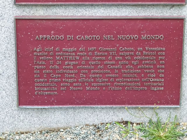
The Cabot Trail is often referred as Nova Scotia's masterpiece.  It is a two lane road that loops the northernmost area of Cape Breton Island.  This approximately 400 mile  kilometer road is surrounded by the Atlantic Ocean the Bay of Fundy, the  Northumberland Strait and the Gulf of St. Lawrence.  The landscape is majestic with rugged stones, an abundance of wildlife, and this summer as I looked for a cool place to escape it was as warm as Florida.  That aside, it was first circumnavigated in 1497 by Giovanni Caboto a Venetian on the sailing ship Matthew employed by Henry the VII who left Bristol England searching for a way West to get to the orient.  Why they don't call it the Caboto Trail only attests to how the English established first dibs on everything even when the deeds were undertaken by other nationals.


In a remote corner of the Cabot trail, one of the few places where Caboto is acknowledged


The majesty of the landscape is equal in beauty to its namesake of Scotland.  The cliffs are windswept with abundance of exotic birds soaring and diving into a sea filled with whales and what used to be the richest bounty of fish in the planet.  The road snakes up and down cliffs through ravines exposing fishing villages and cobbled beaches with all manner of luxury or plain accommodations.  The following are a series of images taken throughout our journey as far as the Ingonish Campground in the Cape Breton Highlands National Park.


The Celtic Lodge on Ingonish Bay offered a great contrast to what we were experiencing camping in the rain with mosquitos buzzing left and right.  I took a break from my outdoor life and got dressed in my finest and went to have a delicious evening meal and cocktails in this beautiful dining room.   You have to treat yourself whenever you can!

Wednesday, October 2, 2013

Nova Scotia on the way to the Cabot Trail

A soaked tent  set up on soft moss covered bank with one of the greatest views in the trip  at
Battery Provincial Park
We escaped the rains on Prince Edward Island and paid our $44.00 toll to exit the Confederation Bridge on a clammy and wet day.  Little did we know that at our destination the rain would be of tropical proportions. We also had a 300 plus mile long drive ahead of us  to get our next campsite.  The drive initially proved beautiful with all manner of villages and fishing towns that by now had become the norm.  We had a few stops but we were headed to the principal location of our Canadian adventure - Cape Breton and the Cabot trail.  The Trans-Canadian highways we had experienced were beautiful multi lane roads without ever a toll.  This far north and with a limited population at hand, even the Trans-Canadian Highway was just a two lane road with a passing lane every so often.


Marti and I had each driven our own hybrid cars from Florida.  We had started the journeys with different itineraries and had linked up in Maine for the 4th of July.  We had planned part of the camping trip in Florida and had left wiggle room to adapt to opportunities.   We had envisioned about three weeks of camping.  Eventually she would return to Florida and I would continue further north into Quebec to visit the old French cities of Quebec and Montreal.  I would then do the rounds visiting friends near Ottawa, Vermont, New York and my old home in New Jersey.
Another wet day on the road to Louisburg

One of the discoveries we made along the trip was that the reconstructed Fortress of Louisburg was celebrating 300 year anniversary (well, sort of) and we were headed there the day of the opening festivities.  I say sort of because Louisburg, the principal French settlement on Cape Breton Island (then called Ile Royale {Royal Island} was constructed in 1713 and burned down by the British in 1758.  The Canadian Government began a 25 million dollar reconstruction in 1965.  Today the finest craftsman have recreated and reinterpreted  historic Louisburg for all to appreciate.  

Main complex of Louisburg seen from visitor center
A further history lesson is required.  Cape Breton is today attached by a causeway to Nova Scotia.  In its history it was an island part of the French possessions in North America.  In 1713 the Treaty of Utrecht (a Dutch city) brought about a peace between Great Britain and France and its ally Spain.  Louis XIV ceded Nova Scotia and New Foundland and Rupert's Land (parts of today Ontario, Manitoba and Nunavut) Spain ceeded Spanish Netherlands, Naples, Sardinia, Milan to the Holy Roman Emperor and Gibraltar and Minorca to Great Britain.  The land grab that followed by the British eventually laying siege to all French possessions in North America ended by the Battle of the Fields Abraham in 1759.  This battle fought outside the walls of Quebec City in farm fields of a man named Abraham lasted all of 15 minutes with the French surrendering (well, sort of){that story when we get to Quebec}.  

The following are images of the visit.  We arrived during a partially sunny day and then the skies opened up and it poured.  In many ways we experienced the place like the French settlers who lived there so long ago. Part of the interpretive nature had people in various buildings and locations telling about fishing, soldiering and surviving in Louisburg.

guard in character searching for British spies 
even the crest looks like Louis 14
All the canons did not manage to defend the fort as the British siege came from an unprotected swamp

fine central building housing barracks, governor and chapel
massive timber stairs into governor's apartment
Governor's dining room
Governor's bedchamber

Chapel

recreated formal garden
Celebration participants
Painting of a sea battle outside fortress
Royal Gate in honor of Louis 14 in case he visited
Fiske Kimball was a talented architect enlisted by John D Rockefeller Jr to create Williamsburg Virginia in the early 1930's.  This new way of creating art, history and commerce served as a good example for the Canadian's government effort to recreate  a historic legacy and provide employment to an area that had been depressed due to loss of employment with the closing of many mines in Nova Scotia.  It is hard to imagine today that this historic photograph was the starting point of the study and interest of historians, archeologists and architects to recreate the Louisburg we see today.  Happy 300th Birthday, sort of.
Massive warehouse